INVESTIGATING AQUIFER VULNERABILITY IN THE SAIGON RIVER BASIN (VIETNAM) USING TIME DOMAIN ELECTROMAGNETIC SOUNDINGS (TDEM)
We are pleased to introduce the research article titled "Investigating Aquifer Vulnerability in the Saigon River Basin (Vietnam) Using Time Domain Electromagnetic Soundings (TDEM)". This study is a collaboration between scientists from Ho Chi Minh City University of Technology (HCMUT), IGE, and UMR G-eau: Thanh Truong Quoc (GEOPET - HCMUT), Marc Descloitres (Institut de recherche pour le développement (IRD)/IGE), Phong Nho Tan (GEOPET - HCMUT), Tu Anh Tran (GEOPET - HCMUT), Sarah Tweed (IRD/G-Eau), Anatoly Legchenko (IRD/IGE), Tin Trung Nguyen (CARE - HCMUT), Thanh Long Tran (Fac Civil Eng - HCMUT), Xuan Van Tran (GEOPET - HCMUT), and Laurent Oxarango (IGE). The paper is published in the journal Environmental Advances (2025).
This work is part of the IJL CARE research project / Work package 2: Groundwater resources and recharge.
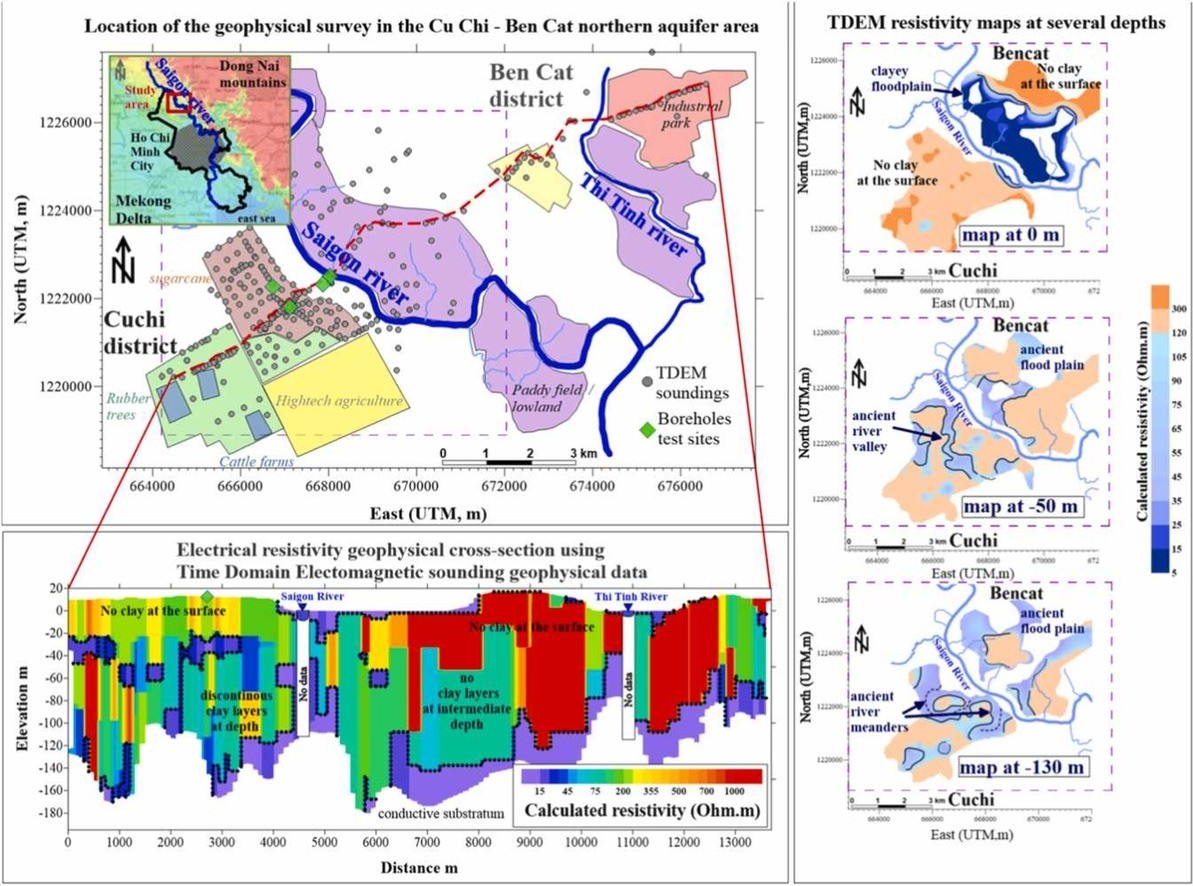
In this rapidly growing economic region facing with land subsidence, aquifers are a key resource for agricultural and urban uses. This study focuses on the vulnerability of shallower aquifers (0-150 m deep) in elevated zones (+15 m asl), strategically considered as "refuge zones" compared with the inundated lowlands. Clayey aquitard layers were analyzed for their capacity to protect, or not, the aquifer from infiltration of polluted waters. 260 Time Domain Electromagnetic (TDEM) soundings were used to detect clayey layers and create resistivity maps.
TDEM results revealed an unknown geometry of the aquifer-aquitard down to 150 m depth. On the right bank of the river, there were no superficial clayey layers to protect the aquifer from infiltrating pollutants. In comparison, on the left bank, the flood plain is clay-rich, thus favoring runoff rather than infiltration of polluted waters. Observations of the deeper clayey layers highlighted discontinuities, which follow ancient meanders and floodplain shapes that originated from quaternary transgression sequences. These results provide clues for understanding past regional sedimentation processes, and links with current aquifer vulnerability. Such information n is critical for the strategic planning of elevated areas of coastal megacities such as Ho Chi Minh City.
For detailed insights, access the full article here: https://doi.org/10.1016/j.ejrh.2025.102306
562